Finally the silence is over. Happy New Year to everybody - we're just gonna ignore the fact that it's already Feb 6th.
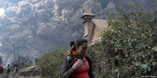
I'm gonna start the year with an issue that has come up quite a bit lately when talking with friends and family... Eruption forecasting. Yep, I said it, the dreaded term. Sad events like 15 deaths due to the latest activity at
Mt. Sinabung in Indonesia bring the forecasting topic into the focus of the public from time to time.
 |
| Most recent eruption at Mt. Sinabung, Indonesia, Feb 1, 2014. Image from Twitter, @BBCBreaking. |
So let's look into this a bit more. We're gonna learn about what signs of volcanic activity there are are at the surface, what we can do to monitor them, and what the difficulties with forecasting are.
To explore this topic in the detail it deserves, however, we need to start with something very basic: The difference between "forecast" and "prediction". If you look up the two words in a dictionary you will most likely find little difference between their meanings, often they're even listed as synonyms of each other. In science, however, things are a little different. In particular, in seismology (the study of earthquakes) the two terms have very distinct meanings: A "forecast" assesses the likelihood of an earthquake of a certain magnitude in a given area and time span, e.g. "there is a 1 in 10 probability that a magnitude 7 earthquake will occur in the Pacific Northwest in the next 100 years" (and of course I made this one up). A prediction, in contrast, is much more specific than that, e.g. "a magnitude 7 earthquake will occur within 100 km of Vancouver on Mar 15 at 10:45 AM" (again, obviously I'm making these things up. Yes, my imagination is just wild today.). In seismology, earthquake forecasting is done quite commonly, whereas the general scientific consensus is that earthquake prediction is currently (and might always be) impossible (despite some individuals or groups claiming otherwise...).
So back to volcanoes. In volcano monitoring, people generally don't make "predictions" for when an eruption will occur. Instead, there are short-term forecasts (compared to the long-term forecasts that are usually given in seismology). These forecasts depend on how volcanic activity evolves over time. So what do we use to determine what our volcano is doing? Just like a patient in a hospital might be hooked up to a bunch of instruments measuring vital signs like heart rate, oxygen levels, and body temperature, our volcano is usually hooked up to a bunch of scientific instruments. The vital signs of a volcano are called "precursors", they are for example:
- Earthquakes - we usually look at how many there are say per day or hour, how big they are, at what depth they occur and whether that depth (and horizontal location) changes, and what "type" of earthquake they are. Types of earthquakes might be "regular" earthquakes with (relatively) high frequency waves, earthquakes with (relatively) low frequency waves, a mixture between the two (so-called "hybrids"), or volcanic tremor. These different types of earthquakes sometimes show how magma is moving from one place to another.
- Deformation - how the surface of the volcano changes its shape. We use instruments on the ground and satellites images to determine whether the surface is moving upwards and inflating like when you're blowing up a balloon, or deflating like when you let the balloon go. The deformation usually happens because of a change of pressure below the ground.
- Gases - volcanoes spit out gases in different places most of the time. The gases come - in one way or another - from the magma below the ground. The amount of gases, their temperature, and their type (e.g. sulfur dioxide or carbon dioxide) can help us to determine whether magma might be getting closer to the surface.
- Temperature - sometimes we see higher temperatures around volcanoes on satellite images.
Usually, when we see more earthquakes per hour, a lot of deformation, a lot of gases, and high temperatures, we become worried that magma might be getting close to the surface and ready to cause an eruption. This is what we call "unrest". Volcano observatories use alert or hazard levels to put a number on the state of volcano unrest. Below are examples of two different alert/hazard level systems from two different volcano observatories (GeoNet, New Zealand; and Montserrat Volcano Observatory, Lesser Antilles):
 |
| Alert levels for frequently active volcanoes in New Zealand (courtesy of GeoNet) |
You can see that Montserrat has zones in addition to the hazard levels, and access to the zones is controlled based on what the hazard level is. The way the alert/hazard level is determined depends on the observatory and the specific volcano. The assessment is based on what is known from previous eruptions, scientific studies, and sometimes from other volcanoes.
So far so good. So we now know that a volcano has vital signs like a person, and that we might be able to use them to tell us whether an eruption might be happening soon or now. But of course, things aren't that simple. Unfortunately, volcanoes are like people in another sense (not just in terms of the vital signs analogy): Sometimes they have their own mind, behave in ways that can't be anticipated, and surprise us all. Also, many volcano may look similar but have quite different behaviours from one to another. For example, on some volcanoes precursors build up over weeks or months, whereas on other volcanoes we get only short or no warning at all. Whereas many volcanoes have MORE earthquakes just before an eruption, Telica Volcano in Nicaragua, for example, sometimes goes quiet and has no more earthquakes within an hour or so before explosions (listen to Mel Rodger's recent
podcast on this). Similarly, whereas many volcanoes inflate before eruptions, Uturuncu Volcano in Bolivia has been inflating quite a lot for over 10 years without an eruption (read James Hickey's
blogpost on this).
And just like we have good days and bad days, even one volcano can change its behaviour from one eruption to the next. Obviously in that case we're gonna have a hard time making a good forecast.
Furthermore, the situation is complicated by people. One would think that it's always better to be safe than sorry, so ideally we would move everybody who lives close to a volcano to a safe place? Obviously that's quite unrealistic. Some countries have so many volcanoes that there simply would be no space at all to put people: On the website of the
Global Volcanism Program, a search for volcanoes in Indonesia returns 1182 matches. Granted, some of them might be individual cones on one bigger volcano, or synonyms for different craters and cones, but the number is still really really large if we were to take those duplicates out. Where would we move all the people living close to those volcanoes? We also can't just take them away from their homes, the places where they grew up, away from their property, their fields, their places of income. Even evacuating an area can have significant economic losses the longer it lasts (ignoring the obvious potential loss of life and damage to the economy through the eruption itself). To make things even more complicated, there's the famous "cry wolf" phenomenon. People tend to become less responsive to evacuation orders or instruction for precaution if they have experienced several scenarios in which no eruption occurred in the end. In other words, if you cry wolf too often nobody will believe you anymore.
We can see now that it's quite difficult to give good eruption forecasts. The volcanoes can give us hints, but ultimately we might never know for sure what's going to happen. As scientists, in many cases, we are advising decision makers from a purely scientific perspective with what we know about a volcano and its state. Ideally, there is a dialogue between scientists and decision makers, who will then have to take into account economic, psychological, and other considerations to make a call for evacuation or against it. In
Indonesia at Sinabung, on Friday authorities decided to let people back into the area (but with a certain distance to the volcano) after 10s of thousands had been evacuated following eruptions in the previous weeks. Clearly they did not anticipate the eruption that happened just one day later. A fairly large eruption at
Tungurahua Volcano, Ecuador, which also happened on Saturday, thankfully appears to have had a less fatal outcome than the one in Indonesia. In the end, the outcomes of an eruption depend on many factors. As scientists, we are doing our best to study the processes happening on volcanoes. We might not make huge leaps, but every project is a little step towards understanding our volcanic neighbours a little bit better, and maybe make forecasting a tiny bit more reliable.
