Thursday, 15 May 2014

A little digression: Large earthquakes, Alaska in 1964, and why people in Vancouver should be prepared

Time for a little digression. Let's talk about earthquakes! I've recently come back from a conference in Anchorage, Alaska, the Annual Meeting of the Seismological Society of America. I've only ever been to general geophysics/geosciences, or volcano conferences, so this one was quite the change. Since I study a specific type of earthquakes related to volcanoes I'm a bit in between volcanology and seismology, so it made sense to go.
Around 600 or so seismologists met up to talk about earthquakes and related stuff for three days. Overall it was a great conference. The "small" number of attendees was great - it was really easy to meet lots of people with very similar interests. I also liked the fact that they provided breakfast, lunch, and dinners (mostly). One reason for that is - of course, me being a student - the free food aspect, but there is something else: When you find a table to eat you may opt to find people you know, or you can go to a random table, introduce yourself, and start some interesting science talk. Bigger meetings like AGU are great to catch up with friends in different fields, but generally tend to be more anonymous.
A highlight of the conference was the post-conference field trip. Maybe around 1/3 to 1/2 of the conference attendees got on a bunch of busses to head down south towards the Kenai Peninsula. After leaving Anchorage, we stopped in Whittier, this interesting, tiny Alaskan town. We talked about the effects of the 1964 Alaska earthquakes, one of the biggest earthquakes ever recorded.
Around 5:30 in the afternoon on Good Friday, Mar 27, 1964, an earthquake with a magnitude somewhere around 9.2-9.3 struck just East of Whittier at approximately 25 km depth. The shaking was quite intense for a few minutes, but the real damage came from landslides and a tsunami generated by the earthquake. 

Ruins of a house that was abandoned after the earthquake in 1964, close to Girdwood, Alaska.

There was a heartbreaking account of one family's experience of the earthquake in the Anchorage Daily News a few weeks ago. From a seismology perspective, the earthquake is interesting for one specific subfield: paleoseismology. Paleoseismologists can study the change in ground elevation during the 1964 earthquake. A large area reaching from Kodiak island in the West through Anchorage out to Valdez and further East dropped in elevation during the earthquake because of the new plate configuration. Trees in the region that were slightly above sea level before now found their roots in the salt water, and died within a short time. They can be seen as eerie ghost forests until today. 
Ghost forest close to Girdwood, Alaska.

With the trees, a bunch of grass and shrubs ended up in saltwater. They were quickly covered by sand and silt washed up by the tides, and were preserved. During the field trip, we accessed one of the marsh areas. Our field trip guide Peter Haeussler showed us that when you remove the top layer of silt at the edge of the marsh during low tide, you can see a brown peat horizon. That's the grass from the 1964 earthquake!
Peat horizon from the 1964 earthquake. The brown is grass and shrubs that died after they ended up in saltwater after the earthquake, the grey on top is the silt that quickly covered everything.
A piece of grass that died when it was covered in saltwater after the ground dropped in elevation after the 1964 earthquake.

If you dig down deeper you can find more horizons like that, telling tales from previous large earthquakes in the area. Fossils in those peat horizons can be dated, and we thus know approximately at what intervals large earthquakes occur. Offshore BC and the Pacific Northwest, for example, people were speculating whether large earthquakes can occur at all (there aren't many small ones like e.g. in Alaska or New Zealand). Once paleoseismology became established, people found evidence of large earthquakes offshore the West coast of North America. That's how we know! And because we know now, everybody should consider having an emergency kit in the house. Because what we DON'T know is when the next big one is gonna strike.

Wednesday, 9 April 2014

Mini series on volcano hazards - part III: More on flows

As we learned last time, if an ash cloud becomes to heavy it can collapse and generate a pyroclastic flow. Those flows are not the only ones that happen during or after volcanic eruptions.
An obvious one are lava flows. Depending on the type of volcano, lava can be sticky or runny. The sticky lava tends to be able to store more pressure, and erupt more violently when it finally does. That's what happened e.g. when Mount St. Helens erupted on May 18, 1980. More runny lava tends to erupt less explosively, instead we say the eruptions are "effusive". Of course, as always, there are exceptions to those rules, but it's a good big picture way to think about different styles of eruptions. During effusive eruptions, runny lava either just trickles out of a vent, or sometimes fountains out of fissures. That looks just like a fountain in the park, but with lava instead of water. Here's a video from Kilauea on Hawai`i, you can see lava fountaining out of a fissure, and then - curiously - disappearing into a crack in the ground.
Lava flows are a hazard, mainly because there's not that much that you can do when one shows up in your backyard, like in the photo below. Luckily, at least they're usually quite slow, so you should be able to run (or even walk) away and save yourself.
Lava flow in Kalapana, a now mostly abandoned village on the Big Island of Hawai`i (photo:USGS/Wikimedia Commons)
So that's lava flows. But did I mention mudflows, so-called lahars? Those guys can be quite dangerous too. But what are they? Imagine an explosive eruption with a pyroclastic flow. That kind of eruption often happens on steep, high volcanoes which in turn have snow and ice covering them, sometimes all year round. We learned that pyroclastic flows are really hot, right? What happens to some (or all) of the snow and ice when it gets hit by a pyroclastic flow? It melts. Sometimes a lot. So now we have a lahar - a hot mix of ash, lapilli, bombs, and meltwater rushing down the mountain, sometimes as fast as a car. During that process, lahars often take out trees and other "obstacles", and the more material they carry the more obstacles they can take out, like a tsunami on land. That's exactly what happened in 1985 at Nevado del Ruiz, Colombia. The lahar that was caused by a relatively small explosive eruption was so powerful rushing down into the country surrounding the volcano that it killed over 23,000 people, and left another 10,000 injured and/or homeless.

The same thing can happen long after an eruption has stopped. After the famous eruption of Mount Pinatubo in the Philippines in 1991, not snow and ice but heavy rain started to generate mudflows by mixing with ash on the slopes of the mountain. 
Below an image of a house buried by a lahar. Imagine how powerful the flow must have been!
House buried during lahar, Chaiten, Chile, Dec 2009 (photo: Photovolcanica/Richard Roscoe)
Let's keep in mind that these flows can happen a long time after a volcano has stopped erupting, as long as there is enough loose material on its slopes. Now we need to monitor not only the volcano, but also keep an eye on the weather to make sure we're covering all our bases. Luckily, some smart engineering can help us against this hazard. In some places, e.g. at Sakurajima in Japan, they constructed large, concrete flow channels and dams (sabos) to direct lahars away from villages. Even though sabos can't provide a guarantee that a lahar won't sweep away your house, they're a good start at reducing the risk linked to this particular type of volcanic hazard.


Friday, 28 March 2014

Mini series on volcano hazards - part II: From blows to flows...

So last time we talked about the ash the comes out of the volcano when it blows its top. We said that volcanic bombs can be unpleasant when they hit you - to put it mildly. We also discovered that the ash goes up in the air and eventually (slowly) falls back down and creates some serious problems.
Now unfortunately the ash doesn't always slowly come back down to the ground. An ash cloud is a mixture of broken up pieces of magma of different sizes (remember? Ash, lapilli, and bombs), and a bunch of hot gases. The volcano spits out that mixture, and when there is a lot of the hot gases and not quite as much ash the mixture rises up into the air. It can go quite high, and then get transported with the wind and create a big mess for air travel (which we saw happening all the way from Iceland to Europe 4 years ago). Why does the ash cloud rise up so high? In very simple terms it's the same principle as a hot air balloon: The mixture of hot gases and ash is less dense than the surrounding air, so it rises. Sometimes, the amount of ash in the ash cloud is too much though - so the mixture can't rise. Instead it does what every heavy object does when you throw it up into the air: It comes back down, sometimes really really quickly. When this happens we call it a "pyroclastic flow" (from the Greek words for fire and broken in pieces). Check out the video from Earth Uncut TV below to see what a pyroclastic flow looks like.


As you can see in the video, these pyroclastic flows can get quite fast. With speeds of several 100 km/h, they're too fast to drive away from in a car. They're also quite hot: The mixture is almost as hot as the lava that comes of the volcano, something like 600-800˚ C. That's over 3 times hotter than the temperature in your oven when you make pizza. So imagine something that hot hits you at speeds faster than a race car. You can imagine what the outcome would be... In 1991, the Japanese volcano Unzen erupted and created a pyroclastic flow that (in)famously killed over 40 people, including Katia and Maurice Krafft, a couple of volcanologists. 
Has anybody seen the movie Pompeii that came out a few weeks ago (at least in North America, some places in Europe etc might have to wait a bit longer...)? It's based on a true story of a volcanic eruption and a pyroclastic flow of Mount Vesuvius in 79 AD. The pyroclastic flow from that eruption covered the city of Pompeii and everybody in there in several meters of ash. People's bodies were preserved in that ash, and at the historic site in Italy we can still see their casts in the positions they took in the last seconds of their lives that ended so abruptly almost 2000 years ago - a stark reminder of the power of volcanic eruptions.
Below another video (timelapse, by Photovolcanica) of a pyroclastic flow from Sinabung in Indonesia earlier this year. This particular one had a different trigger mechanism - the collapse of part of the volcanic edifice during the eruption. The outcome, however, can be as devastating as the pyroclastic flows generated by ash clouds. In fact, e.g. the Japanese example above was a pyroclastic flow created by a collapse of a part of the volcano.


As we will see next time, pyroclastic flows aren't the only flowing hazards on volcanoes. Water, ash, dirt, and bigger particles can create lahars, and of course lava itself can flow down the slopes of a volcano. But we'll save these topics for another time.

Monday, 24 March 2014

Add on - a volcanic bomb

Just to follow up on the last post, a photo I managed to dig up from the depths of my harddrive, from our 2007 Canary Islands fieldtrip. It's a volcanic bomb, on the island of La Palma. If you look carefully you can even see structures that show that the lava was still hot and deformable when it flew out of the volcano. Wouldn't wanna get hit by that thing...

Volcanic bomb, La Palma, Canary Islands. Photo: K. Unglert

Thursday, 20 February 2014

Mini series on volcano hazards: Ash and more

Since I was talking about eruption forecasting in the last post I think it's time to talk a bit about why we even care. Ok, we all know that volcanic eruptions can be dangerous, and that people like me are trying to understand them better, but what specifically can be a hazard during or after an eruption?
This is going to be a mini series - each post will cover a new hazard. So let's start with a very obvious one: Volcanic ash, lapilli, and bombs. What do these terms mean?
Explosive eruptions usually send pieces of rock into the air. All of the pieces smaller than 2 mm diameter are called ash. Everything between 2 mm and 6.4 cm is called lapilli, and everything larger than that is called volcanic bombs. Look at the photo below to see an explosion with a bunch of ash and some really large bombs.
The smaller the piece the further it can get away from the volcano - either because of the explosive power of the eruption, or because it gets carried away by wind in the atmosphere. Bombs are really dangerous when you're close to volcanic eruptions - it's probably not very healthy to get hit in the head with a 10 cm or so potentially hot rock that comes flying through the air. 
Explosive eruption at Sakurajima Volcano, Japan, Jul 2013. You can see an ash cloud rising. Can you spot the bombs at the bottom right of the ash cloud? Look at the size of the trees and the mountain, and estimate how large the bombs must be. Definitely wouldn't wanna get too close! Photo: K.Unglert

Ash is obviously also a problem close to the volcano: Imagine a huge sandstorm, but in addition particles in the ash are often also hot, and covered with acids from the gases in the eruption. Getting that in your eyes is inconvenient at best, and once you get the fine particles in your nose or lungs it only goes downhill. If you're exposed to ash from volcanic eruptions for a long time (e.g. many years living close to an erupting volcano) it can cause significant health issues. One way to make it at least a little bit better is to wear a mask that covers your face.
Unfortunately that's not the end of it. Even small layers of fine ash on e.g. air conditioning or air plane turbines cause the parts to corrode really fast - that's why airspace usually gets closed off around volcanic eruptions. Remember the eruption of Eyjafjallajökull in Iceland in 2010? Very fine ash particles got blown towards Europe and a lot of people were stranded in airports for days. 
Now imagine ash fall onto the roof of your house: Even a small layer, say 5 cm, can be really dangerous. Why? Well, ash - just like sand - is just tiny pieces of rock. If your roof is 10 m x10 m and has a 5 cm layer of ash on it that's a total volume of 5 cubic meters. Rock has a density of approximately 2600 kg per 1 cubic meter, so 2600 times 5 is? That's right, really really heavy! Even if the ash isn't as dense (and thus heavy) as solid rock, thin layers of ash add up to a heavy weight quite quickly. That makes building collapse a big danger.
Last but not least, there can be impacts on the economy. Ash fall covering crops can cause entire seasons to be without harvest, and animals don't find plants to feed from. Below is a photo of flowers covered in ash at Sakurajima Volcano, Japan, to give you an idea of what the ash can do. Now imagine thicker layers of ash from a bigger eruption!
Flowers covered in ash after a small explosive eruption at Sakurajima Volcano, Japan, Jul 2013. This was only a small eruption, so imagine what it must be like after a large explosive eruption! Photo: K.Unglert
Now we've learned about the main dangers of ash, lapilli, and bombs being thrown out of volcanic vents during an eruption. When the ash is a bit too heavy too rise, or when the ash and the bigger pieces build up over time, they can cause more hazards (pyroclastic flows and lahars), but we're gonna hear about those another time!

Thursday, 6 February 2014

Back with a BANG: Volcanoes 2014 and eruption forecasting?

Finally the silence is over. Happy New Year to everybody - we're just gonna ignore the fact that it's already Feb 6th.
I'm gonna start the year with an issue that has come up quite a bit lately when talking with friends and family... Eruption forecasting. Yep, I said it, the dreaded term. Sad events like 15 deaths due to the latest activity at Mt. Sinabung in Indonesia bring the forecasting topic into the focus of the public from time to time. 
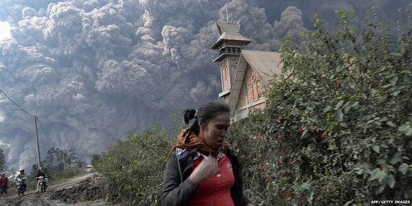
Embedded image permalink
Most recent eruption at Mt. Sinabung, Indonesia, Feb 1, 2014. Image from Twitter, @BBCBreaking.

So let's look into this a bit more. We're gonna learn about what signs of volcanic activity there are are at the surface, what we can do to monitor them, and what the difficulties with forecasting are.

To explore this topic in the detail it deserves, however, we need to start with something very basic: The difference between "forecast" and "prediction". If you look up the two words in a dictionary you will most likely find little difference between their meanings, often they're even listed as synonyms of each other. In science, however, things are a little different. In particular, in seismology (the study of earthquakes) the two terms have very distinct meanings: A "forecast" assesses the likelihood of an earthquake of a certain magnitude in a given area and time span, e.g. "there is a 1 in 10 probability that a magnitude 7 earthquake will occur in the Pacific Northwest in the next 100 years" (and of course I made this one up). A prediction, in contrast, is much more specific than that, e.g. "a magnitude 7 earthquake will occur within 100 km of Vancouver on Mar 15 at 10:45 AM" (again, obviously I'm making these things up. Yes, my imagination is just wild today.). In seismology, earthquake forecasting is done quite commonly, whereas the general scientific consensus is that earthquake prediction is currently (and might always be) impossible (despite some individuals or groups claiming otherwise...). 

So back to volcanoes. In volcano monitoring, people generally don't make "predictions" for when an eruption will occur. Instead, there are short-term forecasts (compared to the long-term forecasts that are usually given in seismology). These forecasts depend on how volcanic activity evolves over time. So what do we use to determine what our volcano is doing? Just like a patient in a hospital might be hooked up to a bunch of instruments measuring vital signs like heart rate, oxygen levels, and body temperature, our volcano is usually hooked up to a bunch of scientific instruments. The vital signs of a volcano are called "precursors", they are for example:
  • Earthquakes - we usually look at how many there are say per day or hour, how big they are, at what depth they occur and whether that depth (and horizontal location) changes, and what "type" of earthquake they are. Types of earthquakes might be "regular" earthquakes with (relatively) high frequency waves, earthquakes with (relatively) low frequency waves, a mixture between the two (so-called "hybrids"), or volcanic tremor. These different types of earthquakes sometimes show how magma is moving from one place to another.
  • Deformation - how the surface of the volcano changes its shape. We use instruments on the ground and satellites images to determine whether the surface is moving upwards and inflating like when you're blowing up a balloon, or deflating like when you let the balloon go. The deformation usually happens because of a change of pressure below the ground.
  • Gases - volcanoes spit out gases in different places most of the time. The gases come - in one way or another - from the magma below the ground. The amount of gases, their temperature, and their type (e.g. sulfur dioxide or carbon dioxide) can help us to determine whether magma might be getting closer to the surface.
  • Temperature - sometimes we see higher temperatures around volcanoes on satellite images.
Usually, when we see more earthquakes per hour, a lot of deformation, a lot of gases, and high temperatures, we become worried that magma might be getting close to the surface and ready to cause an eruption. This is what we call "unrest". Volcano observatories use alert or hazard levels to put a number on the state of volcano unrest. Below are examples of two different alert/hazard level systems from two different volcano observatories (GeoNet, New Zealand; and Montserrat Volcano Observatory, Lesser Antilles):
Alert levels for frequently active volcanoes in New Zealand (courtesy of GeoNet)

Hazard levels for Soufrière Hills Volcano, Montserrat (courtesy of Montserrat Volcano Observatory)
You can see that Montserrat has zones in addition to the hazard levels, and access to the zones is controlled based on what the hazard level is. The way the alert/hazard level is determined depends on the observatory and the specific volcano. The assessment is based on what is known from previous eruptions, scientific studies, and sometimes from other volcanoes.

So far so good. So we now know that a volcano has vital signs like a person, and that we might be able to use them to tell us whether an eruption might be happening soon or now. But of course, things aren't that simple. Unfortunately, volcanoes are like people in another sense (not just in terms of the vital signs analogy): Sometimes they have their own mind, behave in ways that can't be anticipated, and surprise us all. Also, many volcano may look similar but have quite different behaviours from one to another. For example, on some volcanoes precursors build up over weeks or months, whereas on other volcanoes we get only short or no warning at all. Whereas many volcanoes have MORE earthquakes just before an eruption, Telica Volcano in Nicaragua, for example, sometimes goes quiet and has no more earthquakes within an hour or so before explosions (listen to Mel Rodger's recent podcast on this). Similarly, whereas many volcanoes inflate before eruptions, Uturuncu Volcano in Bolivia has been inflating quite a lot for over 10 years without an eruption (read James Hickey's blogpost on this).
And just like we have good days and bad days, even one volcano can change its behaviour from one eruption to the next. Obviously in that case we're gonna have a hard time making a good forecast. 

Furthermore, the situation is complicated by people. One would think that it's always better to be safe than sorry, so ideally we would move everybody who lives close to a volcano to a safe place? Obviously that's quite unrealistic. Some countries have so many volcanoes that there simply would be no space at all to put people: On the website of the Global Volcanism Program, a search for volcanoes in Indonesia returns 1182 matches. Granted, some of them might be individual cones on one bigger volcano, or synonyms for different craters and cones, but the number is still really really large if we were to take those duplicates out. Where would we move all the people living close to those volcanoes? We also can't just take them away from their homes, the places where they grew up, away from their property, their fields, their places of income. Even evacuating an area can have significant economic losses the longer it lasts (ignoring the obvious potential loss of life and damage to the economy through the eruption itself). To make things even more complicated, there's the famous "cry wolf" phenomenon. People tend to become less responsive to evacuation orders or instruction for precaution if they have experienced several scenarios in which no eruption occurred in the end. In other words, if you cry wolf too often nobody will believe you anymore.

We can see now that it's quite difficult to give good eruption forecasts. The volcanoes can give us hints, but ultimately we might never know for sure what's going to happen. As scientists, in many cases, we are advising decision makers from a purely scientific perspective with what we know about a volcano and its state. Ideally, there is a dialogue between scientists and decision makers, who will then have to take into account economic, psychological, and other considerations to make a call for evacuation or against it. In Indonesia at Sinabung, on Friday authorities decided to let people back into the area (but with a certain distance to the volcano) after 10s of thousands had been evacuated following eruptions in the previous weeks. Clearly they did not anticipate the eruption that happened just one day later. A fairly large eruption at Tungurahua Volcano, Ecuador, which also happened on Saturday, thankfully appears to have had a less fatal outcome than the one in Indonesia. In the end, the outcomes of an eruption depend on many factors. As scientists, we are doing our best to study the processes happening on volcanoes. We might not make huge leaps, but every project is a little step towards understanding our volcanic neighbours a little bit better, and maybe make forecasting a tiny bit more reliable.


Friday, 11 October 2013

In which we get a mini update before I bury myself in silence again

So I'm really quite busy this fall trying to get a bunch of work done. Expect a more or less silent time until I have a life again in January... In the mean I will try to post a least some little snippets for entertainment.
Number one: The Science news cycle! Almost in line with my last post about the Alaskan underground fire...